| History of the OPR - East Portland Branch - Molalla Branch - Videos of the OPR in Action News & Upcoming Events - Photos of Past Events - Roster of the OPR Special Features |
| Last Update: February 7, 2011 |
| History of the OPR - East Portland Branch - Molalla Branch - Videos of the OPR in Action News & Upcoming Events - Photos of Past Events - Roster of the OPR Special Features |
| Copyright � 2004-2012 All Rights Reserved |

| THEN & NOW on the Oregon Pacific Railroad |

| This new page is about comparing historical photos of the OPR and related predecessor railroads to what those photos would look like today in those same areas. This will be an ongoing project as we continue to source older photos and then try to go out and match those photos. Photos on the left are historical photos, most of which were taken prior to the OPR take over of the railroad in 1991. A few photos may be as recent as the 1980s, but most are much older, dating back to the 1960s and older. Photos on the right are the modern era photos that were taken very recently. This page is an on going project and more photos will be added soon. Special thanks to OPR Volunteer Kevin Novak who took many of the "now" photos shown on this page. |


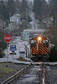
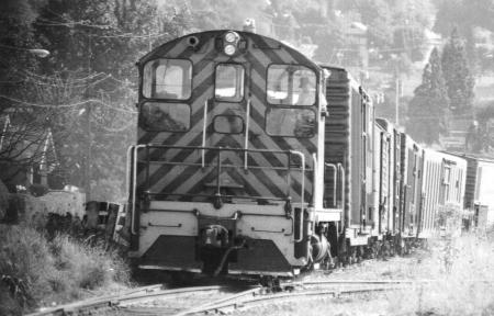
| Photo on the left was taken by Richard Samuels in the early 1960s, showing PRTD No. 100 coming up the hill from the Milwaukie Industrial Park off of the modern day AmeriCold spur. Photo on the right was taken in Feb, 2011 by Kyle Weismann-Yee (far right photo taken by Scott Lothes at the same time). Again showing the exact same engine, No. 100, coming up the hill from the Milwaukie Industrial Park. In the "now" photo, the No. 100 is approximately 100 feet north of where the "then" photo was taken. |


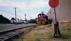
| Photo on the left was taken in 1942 and shows PEPCo Electric Motor 1408 stopped at Golf Junction with a freight. Photo on the right was taken in Oct, 2009 and shows the PRTD No. 100 stopped with a freight in the exact same location. This was an attempt to recreate the photo on the left so that it could be displayed on this website. |
| Stay Tuned, More "Then & Now" Photos Coming Soon! |

| Photo on the left was taken in the 1950s by Robert T McVay shows a trolley north bound, just south of the Ross Island Bridge. Photo taken from the Ross Island Bridge looking south. Photo on right from today is coming soon |
| Coming Soon |
| Photo on the left was taken in the early 1960s, shows No. 100 switching out cars on the Helico Spur. Photo on right from today is coming soon |
| Coming Soon |


| Photo on the left was taken in the 1950s by Robert T McVay shows a trolley south bound, just south of Tacoma Steet. Photo taken from the Sellwood Bridge looking north. Photo on the right was taken in October, 2011 of the exact same view. |
| Photo on the left was taken sometime in the 1960s or early 1970s, by Richard Samuels and shows the PRTD No. 200 in the large through cut at the west end of the former Boring Branch of the PRTD. On the right is the same area in late 2011, about 20 years after the tracks were pulled up and replaced with the Springwater Bike Trail. |

| Photo on the left was taken in the mid 1980s when Richard Samuels followed the Portland Traction Company crew using the No. 200 locomotive for the last time before it was sold off. Photo on right is taken in the same place in late 2011. |

| Photo on the left was taken in 1987 by Richard Samuels when the SP&S 700 was pulled out of Oaks Park. A lot of changes took place when the Springwater Trail was cut in. The mainline was shift back to the left and the old spur that once connected the steam locomotive display of the SP&S 700 (and SP 4449 earlier) is all long gone, replaced by a new trail system. Photo on right taken in October, 2011. |
| Photo on the left was taken in 1987 by Richard Samuels when the SP&S 700 was pulled out of Oaks Park. A lot of changes took place when the Springwater Trail was cut in. The mainline was shift back to the left and the old spur that once connected the steam locomotive display of the SP&S 700 (and SP 4449 earlier) is all long gone, replaced by a new trail system. Photo on right taken in October, 2011. |


| Photo on the left was taken in 1987 by Richard Samuels when the SP&S 700 was pulled out of Oaks Park. A lot of changes took place when the Springwater Trail was cut in. The mainline was shift back to the left and the old spur that once connected the steam locomotive display of the SP&S 700 (and SP 4449 earlier) is all long gone, replaced by a new trail system. Photo on right taken in October, 2011. |
| Photo on the left was taken in 1977 by Louis Thelen and shows the No. 100 passing Linn Street. Photo on right taken in October, 2011. Note how much the trees in the foreground have grown. |


| Photo on the left was taken in the late 1980s or possible 1991, just after Richard Samuels purchased the Portland Traction Company line and began to survey and plan for it's reconstruction and operation. Photo on right was taken in late 2011. In the early 2000s, the track was shifted back to the right, where a former right of way existed, so that the Metro Springwater trail could be built on the western right of way. |


| Photo on the left was taken in the late 1980s or possible 1991, just after Richard Samuels purchased the Portland Traction Company line and began to survey and plan for it's reconstruction and operation. Photo on right was taken in late 2011. This section of track was shifted over the right in 2008 as part of the City of Portland Big Pipe project and also allowed the Springwater Trail to be extended to this area. |


| Photo on the left was taken in the mid 1980s by Richard Samuels while operating one of his smaller locomotives on the Portland Traction Company. It appears that the PTC has had a derailment up ahead. Photo on right was taken in late 2011. In the early 2000s, the track was shifted back to the right, where a former right of way existed, so that the Metro Springwater trail could be built on the western right of way. |


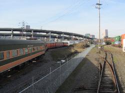
| Photo on the left was taken sometime in the 1980s by Richard Samuels showing the PRTD East Portland Yards. Photo on right from Jan, 2012 |

| Photo on the left was taken by Richard Samuels in the 1960s showing No. 100 switching out a lumber mill near where the Gresham City Hall is today. The mill is long gone, replaced by the Gresham Station Mall. On right is the same view looking west down what is the now the light rail alignment at the Gresham City Hall Platform. Kevin Novak photo 2/2012 |

| Photo on the left was taken in the 1960s by Richard Samuels show No. 100 eastbound towards Boring, at Linnemann Junction, adjacent to Paesano's Park near the intersection of Powell Loop and Pleasant View Drive. The spur on which Richard is sitting on the box car taking the photo, once extended to Ruby Jct and was at one time the Mt. Hood Division that ran to the Bull Run Power Plant. On the right the same view on 2/2012 taken by Kevin Novak. The tracks have been pulled up and replaced by the Springwater Trail. |
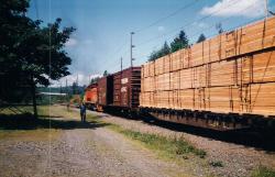
| Photo on the left taken sometime in the 1980s by Richard Samuels, showing the No. 100 westbound on the Gresham Branch at Linnemann Junction. During this period the Portland Traction Company still serviced a sawmill and a cold storage warehouse. Photo on the right taken on 2/2012 by Kevin Novak shows that the Springwater trail has since replaced the tracks. |
| Photo on the left was taken in the 1980s by Richard Samuels on the same day as the above photo. Crew gives hand signals as the PRTD train moves ahead towards East Portland. (Possibly No. 100) Photo on right taken on 2/2012 by Kevin Novak shows the same view today. Again, the tracks are long gone. |
| Photo on the left was taken in 1990 by Richard Samuels as he and his crew were in the process of scrapping the remains of the Boring Branch. Richard Samuel's No. 5100 lettered for the Samuels Pacific Industries, precidesor company to the East Portland Traction Company and today's OPR. Photo on right taken by Kevin Novak on 2/2012 of the same area. |
| Photo on the left was taken in the 1980s by Richard Samuels on the branch to Ruby Jct when the Portland Traction Company was delivering light rail cars to Trimet. The flatcar is on its way back to East Portland. Photo on right was taken by Kevin Novak on 2/2012 showing the only remaining track of the spur that went to Ruby Jct. This track is possibly used for automatic train stop testing by Trimet Max. |
| Photo on the left was taken in the 1980s by Richard Samuels as he documented the last run of the No. 200 before it was sold from the PRTD and replaced by a Southern Pacific SW1500. Photo on right taken by Kevin Novak at 2/2012 shows the same view behind the engineer today. |
| Photo on the right taken perhaps in the 1960s by Richard Samuels looking east on the Gresham Branch at the westbound No. 100. The location is Birdsdale and 202nd Ave. On right, taken by Kevin Novak on 2/2012, showing the PRTD track has since been replaced by the double track of the Max Light Rail Blue Line. |
| Photo on the right taken perhaps in the 1960s by Richard Samuels looking east on the Gresham Branch. The location is Birdsdale and 202nd Ave. On right, taken by Kevin Novak on 2/2012, showing the PRTD track has since been replaced by the double track of the Max Light Rail Blue Line. |


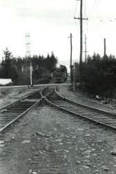
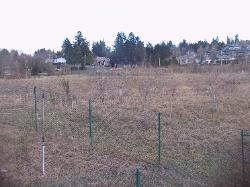
| Photo on the left was taken in the 1960s as No. 100 is pulling around the tight curve at Ruby Jct, headed to Linnemann Jct. On the right, photo take by Kevin Novak on 2/2012. Nothing is recognizable except for a few utility around Ruby Jct. |
| Photo on left taken by Richard Samuels probably in the 1970s showing No. 100 crossing Birdsdale Ave, westbound approaching Ruby Jct. On right taken by Kevin Novak on 2/2012 showing a Max Train using the Max tracks have since replaced the old PRTD tracks. |
| Photo on the left was taken in the 1960s by Richard Samuels and shows No. 100 going past Grant Butte in Gresham, between Ruby Jct and Linnemann Jct. Photo on right taken by Kevin Novak on 2/2012 shows the same area today. Tracks are long gone replaced by a branch of the springwater trail system. |
| Photo on the left was taken in the 1960s by Richard Samuels and shows No. 100 going past Grant Butte in Gresham, between Ruby Jct and Linnemann Jct. Photo on right taken by Kevin Novak on 2/2012 shows the same area today. Tracks are long gone replaced by a branch of the springwater trail system. |


| Photo on the left was taken at the same time and area as the above photo, on the SW Highland Drive Bridge, near the intersection of W Powell Blvd and SE 182nd. The crew is likely inspecting flood damage from Johnson Creek. Photo on right taken by Kevin Novak on 2/2012 of the same area. |